On July 2, a solar eclipse will sweep across the South Pacific and parts of South America.
In parts of Chile and Argentina, skywatchers will witness a total eclipse of the sun, in which the moon will block the sun from view — with the exception of its wispy corona. In other parts of South America, skywatchers can see a partial eclipse, and the sun will look like the moon took a "bite" out of its face.
With this photo guide, you can find out exactly where the eclipse will be visible and what it will look like. If you're not in the path of the eclipse, be sure to check out these eclipse webcasts from various observatories in its path.
Related: Total Solar Eclipse 2019: A Complete Guide
Visibility Map
(Image credit: NASA's Scientific Visualization Studio)
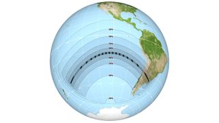
This map represents the path that the moon's shadow will take across the Earth's surface during the total solar eclipse. Outside the path of totality, this map shows the percentage of the sun's disk that will be covered by the moon at maximum partial eclipse.
Before the eclipse reaches South America, it will first pass over a few remote islands in the Pacific Ocean. The first place to see the eclipse will be Oeno Island, which will experience 2 minutes and 53 seconds of totality starting at 10:24 a.m. local time (1824 GMT). Totality will narrowly miss Easter Island, where skywatchers will see the moon cover up to about 80% of the sun's disk.
The moment of greatest eclipse will occur at a point about 1,600 miles (2,600 km) southwest of Isla Isabela of the Galapagos Islands, where totality lasts a whopping 4 minutes and 32.8 seconds. Unfortunately, that's happening over open water, so unless there's an airplane or boat passing though, there won't be any humans around to see it.
Eclipse Animation
(Image credit: NASA's Scientific Visualization Studio)
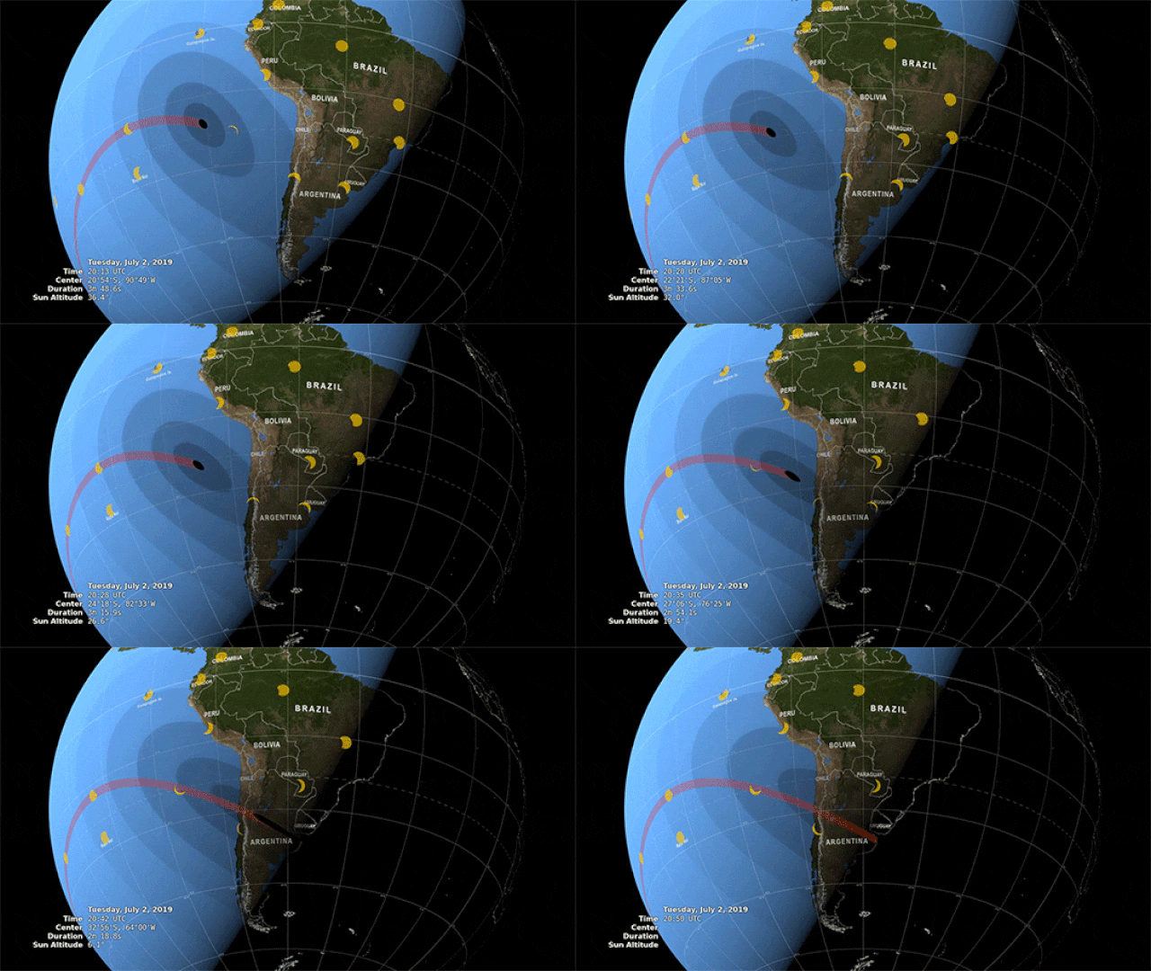
An animation of the total solar eclipse on July 2 shows the path the moon's shadow will take across the South Pacific Ocean and South America.
Totality in South America

(Image credit: NASA's Scientific Visualization Studio)
A more detailed map shows the path of totality across Chile and Argentina. Here you can see features including national boundaries, major roads and cities along the path. The shape of the umbra, or the inner part of the moon's shadow, is shown at 3-minute intervals and labeled with the local time zones at its center.
Totality will make its first landfall in South America near La Serena, Chile. The partial eclipse there begins at 3:15 p.m. local time (1915 GMT), and totality begins at 4:38 p.m. local time (2038 GMT). La Serena will experience 2 minutes and 17 seconds of totality.
From there, the eclipse will move southeast across Chile and into Argentina before disappearing into the sunset just south of Montevideo, Uruguay. Most of South America will see at least a partial eclipse, but the path of totality is only about 95 miles (150 kilometers) wide.
To find out the exact circumstances of the eclipse's visibility from a specific location, check out this interactive map by timeanddate.com.
Path of Totality in Chile

(Image credit: ESO/P. Horálek/M. Druckmüller/P. Aniol/Z. Hoder/S. Habbal/L. Calçada)
This chart shows how the eclipse will appear from different locations in Chile. To the right is an artist's impression of totality over the European Southern Observatory's La Silla Observatory, which is located north of La Serena in Chile's Atacama Desert.
Stages of the Eclipse
(Image credit: ESO/P. Horálek/M. Druckmüller/P. Aniol/Z. Hoder/S. Habbal)
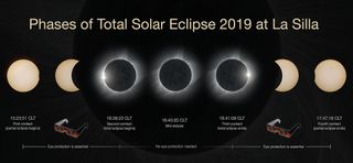
This timeline shows how and when the phases of the total solar eclipse will progress as seen from the La Silla Observatory.
Eclipse Progression Over La Silla
(Image credit: ESO/B. Tafreshi (twanight.org)/P. Horálek)
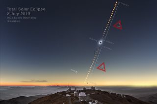
This ESO infographic shows the predicted path of the eclipsed sun in the sky above La Silla. The partial phase of the eclipse will end just before sunset there. Farther east, the sun will set before the eclipse is over.
Visible Planets and Stars
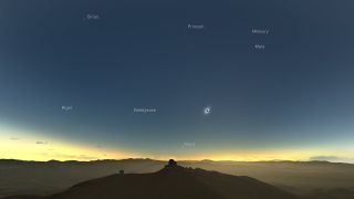
(Image credit: M. Druckmüller, P. Aniol, K. Delcourte, P. Horálek, L. Calçada/ESO)
During totality, the sky will darken enough to reveal planets and stars that are not otherwise visible from the Southern Hemisphere this time of year, because they're above the horizon during the daytime.
Of course, you'll want to spend your totality looking at the eclipsed sun. But if a cloud happens to block your view of the corona, these are still a good reason to keep looking up!
Be sure to check our eclipse skywatching guide for more details about the visible stars and planets.
How to Observe the Sun Safely
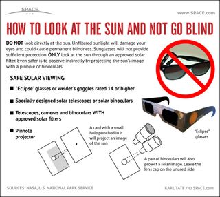
(Image credit: Karl Tate, Space.com Contributor)
You should never look directly at the sun, but there are ways to safely observe an eclipse. See how to safely observe a solar eclipse with this Space.com infographic.
Read more eclipse-observing tips here:
A Solar Eclipse Can Blind You (Read This Before Looking at the Sun!)
Solar Eclipse Glasses: Where to Buy the Best, High-Quality Eyewear
Things I Used to Observe an Eclipse, Rated
Eclipses to Come
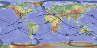
(Image credit: T. Matsopulos/NASA)
If you missed this year's total solar eclipse, it's not too late to start planning for the next one! Here's a map of all the total solar eclipses coming up until the year 2040.
Email Hanneke Weitering at hweitering@space.com or follow her @hannekescience. Follow us on Twitter @Spacedotcom and on Facebook.
Bagikan Berita Ini


0 Response to "Total Solar Eclipse 2019: Path, Viewing Maps and Photo Guide - Space.com"
Post a Comment